 Paikkatietohakemisto
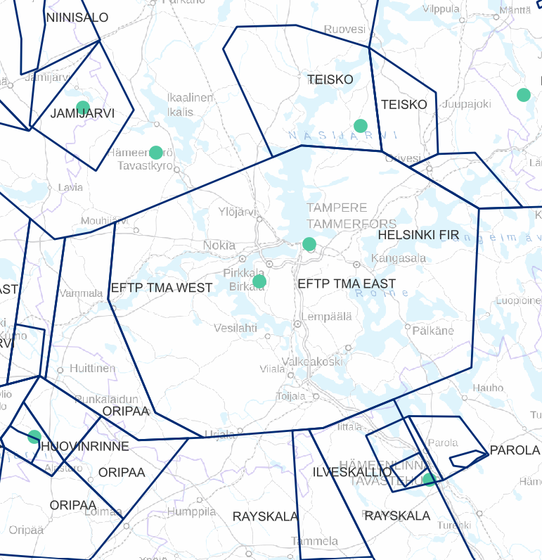
Transport networks
Type of resources
Available actions
Topics
Keywords
Contact for the resource
Provided by
Years
Formats
Representation types
Update frequencies
Service types
Scale
-
FTIA INSPIRE Transport Networks Theme Dataset is a dataset depicting the Transport Networks covering the whole of Finland. It contains the following INSPIRE feature types: Road network, Rail network, Waterway network and Air transport network. The dataset is available via the FTIA INSPIRE Download Service (WFS) for Transport Networks and it can be viewed via the FTIA INSPIRE View Service (WMS) for Transport Networks.
-
Air traffic network-product is a link-knot routing dataset compliant with INSPIRE requirements. It includes f.ex. flight routes and aerodromes. Data shall not be used for operational flight activities or flight planning. INSPIRE Air Traffic Network-product includes spatial information of air traffic network in accordance with the INSPIRE Directive. The data has been retrieved from the EAD database maintained by Eurocontrol. Information is updated regularly but is not constantly up to date. Data can be used for purposes that are in accordance with the INSPIRE Directive, but shall not be used for operational flight activities or flight planning. ANS Finland www.ais.fi –site provides information for operational flight activities or flight planning
-
FIN Aineiston tarkoituksena on: -Identifioida tie- ja rata-alueet, joiden varrella esiintyy uhanalaisia ja silmälläpidettäviä lajeja -Identifioida tie- ja rata-alueet, joiden varrella esiintyy hyviä elinvoimaisia niittyindikaattorilajeja (hyönteisten mesi- ja ravintokasveja) -Identifioida tie- ja rata-alueet, joiden varrella esiintyy suojelualueita -Identifioida tie- ja rata-alueet, joiden varrella esiintyy komealupiinia tai kurtturuusua -Identifioida tie- ja rata-alueet, joiden varrella esiintyy komealupiinia tai kurtturuusua uhanalaisten lajien lisäksi -> Löytää herkät alueet ja paikallistaa vieraslajien uhka Tieto esitetään 1 kilometrin ruuduissa. Aineistosta on julkaistu kaksi erillistä versiota. -VaylanvarsienVieraslajitJaArvokkaatElinymparistot_avoin: Avoin versio, jonka lajitietoa on karkeistettu mahdollisista herkistä lajeista johtuen. Aineisto kuuluu SYKEn avoimiin aineistoihin (CC BY 4.0) ja sitä saa käyttää lisenssiehtojen mukaisesti -VaylanvarsienVieraslajitJaArvokkaatElinymparistot_kayttorajoitettu: Alkuperäinen karkeistamaton versio. Tämä versio on vain viranomaiskäyttöön eikä kyseistä aineistoa saa jakaa Aineistosta on tehty tarkempi menetelmäkuvaus https://geoportal.ymparisto.fi/meta/julkinen/dokumentit/VierasVayla_Menetelmakuvaus.pdf sekä muuttujaseloste https://geoportal.ymparisto.fi/meta/julkinen/dokumentit/VierasVayla_VariableDescription.xlsx ENG The purpose of the material is to: -Identify road and rail areas that have nearby observations of endangered and near threatened species -Identify road and rail areas with good meadow indicator plant species -Identify road and rail areas along which there are protected areas -Identify the road and rail areas along which there are observations of Lupinus polyphyllus or Rosa rugosa observations -Identify the road and rail areas along which there are Lupinus polyphyllus or Rosa rugosa observations in addition to sensitive species -> Finds sensitive areas and identify the overall threat of alien species The data is presented in 1-kilometer square grid cells. There are two separate versions of the data. -VaylanvarsienVieraslajitJaArvokkaatElinymparistot_avoin: Open access version, in which its species-related parts have been simplified due to data restriction issues. The material belongs to Syke's open materials (CC BY 4.0) and may be used in accordance with the license terms. -VaylanvarsienVieraslajitJaArvokkaatElinymparistot_kayttorajoitettu: Original version. This version is only for official use and the material in question may not be shared. A more precise description about the data procedures can be found from (In Finnish) https://geoportal.ymparisto.fi/meta/julkinen/dokumentit/VierasVayla_Menetelmakuvaus.pdf Furthermore, all the variables in the data are explained in this bilingual variable description https://geoportal.ymparisto.fi/meta/julkinen/dokumentit/VierasVayla_VariableDescription.xlsx This dataset was updated with the newest species observations 10/2023. Process code for this can be found from https://github.com/PossibleSolutions/VierasVayla_SpeciesUpdate
-
Vaarallisia aineita voi joutua maantiekuljetusten yhteydessä ympäristöön esimerkiksi säiliöauton ulosajossa. Myös rautateillä säiliövaunun suistuminen raiteelta on mahdollista. Tällöin aineiden kulkeutuminen onnettomuuspaikan läheisyydessä riippuu merkittävästi ympäristön ominaisuuksista, kuten maaperän läpäisykyvystä, pohjaveden syvyystasosta maanpintaan nähden, maanpinnan viettosuunnista ja jyrkkyydestä sekä pintavesiuomien ja vesistöjen läheisyydestä. Liikennealueiden riskiluokituksessa kartoitetaan näitä maaston ominaisuuksia liikenneväylien välittömässä läheisyydessä. Riskiluokitus koostuu neljästä pääluokasta, joilla kullakin on edelleen kolme alaluokkaa. Alla on lyhyt kuvaus kunkin luokan edustamista olosuhteista ja likaantumisriskien kohdistumisesta ympäristössä. Käytetyt maaperäluokat A, B ja C määräytyvät alueen maalajin ja topografian mukaan. Riskiluokkaan A kuuluvat sora- ja hiekka-alueet, joiden ominaisuuksia ovat hyvä läpäisevyys ja heikko nesteiden pidättyvyys. Harjujen ja reunamuodostumien karkeat osat kuuluvat tähän luokkaan. Pohjaveden likaantumisriski on erityisesti AI-luokassa suuri. AIII-luokka edustaa pohjavesimuodostumien yhteysalueita, joilta voi tapahtua joko pohja- tai pintaveden virtausta pohjavesimuodostumaan. Esimerkiksi pohjavesialueisiin rajoittuvat kalliomäet voidaan luokitella AIII-luokkaan kuuluviksi. Raekooltaan hienohiekkaiset maat kuuluvat B-luokkaan. Tässä luokassa läpäisevyys on kohtalainen, ja maalajit pystyvät jonkin verran pidättämään nesteitä. Esimerkkialueita ovat pohjavesialueiden reuna-alueet ja hiekkaiset moreenit. Likaantumisriski kohdistuu pohjaveteen kuten A-luokassakin. A- ja B-alueilla I- ja II-luokan erottaa toisistaan pohjaveden pinnankorkeus. Jos pohjavesi on alle kuuden metrin syvyydellä maanpinnasta, alue kuuluu AI-luokkaan. Alueet, joilla pohjavesi on syvemmällä kuin kuusi metriä, kuuluvat AII-luokkaan. Tämä kuuteen metriin perustuva jako johtuu pohjaveden likaantumisen rajoittamiseksi käytettävän torjuntakaluston laadusta (matala- tai syvätekniikka). BIII-alueet ovat viettomaita, joten niihin kuuluu moreenialueiden lisäksi kalliomaita. BIII-alueilla maahan valuva neste kulkeutuu todennäköisesti vieton suuntaan ja likaantumisriski voi tällöin kohdistua esimerkiksi viettosuunnassa virtaavaan avovesiuomaan, pintavesistöön tai vedenottamoon. C-luokka on heikosti läpäisevien ja tiiviiden maiden luokka. Tähän kuuluvat myös turvemaat sekä keinotekoiset pohjat. CI-luokkaan kuuluvat yleensä pohjavesialueiden läheiset savimaat, joiden alla voi olla vettä johtavia kerroksia. CII-luokka on yleinen erityisesti taajama- ja moottoritiealueilla, sillä se sisältää keinotekoiset pohjat (liittymät, autoliikennealueet) ja loivasti viettävät tai tasaiset savi-, siltti- ja hienorakeiset moreenimaat. C-luokka edustaa ympäristön likaantumisen kannalta verrattain vähäriskisiä alueita; suurin riskitekijä on pohjaveden mahdollinen likaantuminen CI-alueilla. W-luokka poikkeaa muista pääluokista. Siihen kuuluvilla alueilla likaantumisriski kohdistuu pääasiassa pintavesiin. W-luokassa ympäristölle haitallisten aineiden kulkeutuminen voi olla hyvinkin nopeaa; haitta-aineet voivat joutua joko suoraan vesistöön tai päätyä sinne avouomassa virtaavan veden mukana. WII-luokka edustaa ”paljastunutta” pohjavettä, sillä tähän luokkaan kuuluvat erityisesti harjujen laskuojattomat pohjavesilammet. Riskiluokituksessa pyritään antamaan kullekin tieosuudelle vain yksi riskiluokka. Joissain tapauksissa on kuitenkin perusteltua esittää samalla tieosuudella kaksi rinnakkaista luokkaa. Esimerkkitapauksia ovat mm. pohjavesialueet, joilla esiintyy avouomassa virtaavaa vettä. Olosuhteista riippuen likaantumisriski voi kohdistua joko pohjaveteen, pintaveteen tai molempiin. Jos maaperän läpäisykyky on esimerkiksi roudan tai hyvin suuren nestemäärän johdosta pienentynyt, pintaveden likaantuminen voi olla merkittävämpi riskitekijä kuin pohjaveden likaantuminen. Aineisto kuuluu SYKEn avoimiin aineistoihin (CC BY 4.0). Käyttötarkoitus: Vaarallisten aineiden kuljetusreittien suunnittelu ja toiminnan suunnittelu tilanteissa, joissa vaarallisia aineita on joutunut ympäristöön Lisätietoja: https://geoportal.ymparisto.fi/meta/julkinen/dokumentit/LiikennealueRiskiluokitus.pdf
-

The Background map is a dataset product series in raster format that depicts the whole of Finland and that is meant for web use as a background material for thematic data. Its key objects are road names, roads and railways, buildings and constructions, administrative borders, geographical names, waterways, land use and addresses of buildings (from the Digital and Population Data Services Agency). The product belongs to the open data of the National Land Survey of Finland.
-
This dataset represents the density of all IMO registered ships operating in the Baltic Sea. Density is defined as the number of ships crossing a 1 x 1km grid cell. It is based on HELCOM AIS (Automatic Identification System) data. The HELCOM AIS network hosts all the AIS signals received by the Baltic Sea States since 2005. The AIS Explorer allows to compare density maps of different ship types per month: http://maps.helcom.fi/website/AISexplorer/ The data was processed to produce density maps and traffic statistics. All scripts are available in GitHub: https://github.com/helcomsecretariat. The production of these maps have been carried out 2016-2017 through the HELCOM project on the assessment of maritime activities in the Baltic Sea. The underlying AIS data processing work has been co-financed by EU projects Baltic Scope (2015-2017 EASME/EMFF/2014/1.2.1.5) and Baltic Lines (2016-2019, Interreg Baltic Sea Region). In addition, the Ministry of the Environment of Finland supported the work with a special contribution in view of the use of the results in the HOLAS II process.
-
The Plain map series is a simple, plain and readable dataset product series in raster format that depicts the whole of Finland. The product is meant to be used as a background map whose character changes to a guide map in large scales. Impaired vision has been taken into account when designing the product. The key objects presented on the map are roads and railways, road names, buildings and constructions, administrative borders, waterways and other geographical names. The road network, public buildings and texts have been especially emphasised. The most usual limitations of colour vision have been taken into account in the use of colours. The product belongs to the open data of the National Land Survey of Finland.
-
Digiroad is a national dataset under the responsibility of the Finnish Transport Infrastructure Agency (FTIA), which contains the centerline geometries of the road network and traffic-related attributes. Digiroad is an aggregating information system that collects data from the Velho information system of the FTIA, the Topographic Database of the National Land Survey of Finland (NLS), the street information systems of municipalities, and the information systems of a few other authorities (e.g. Helsinki Region Transport HSL). The centerline geometry of Digiroad's road network is obtained from the NLS's Topographic Database. It covers all Finnish highways, streets and private roads, as well as the pedestrian/cycle routes and driving paths in the Topographic Database. In addition, the road network contains some supplementary data to the road line geometry that is not maintained by the NLS. This supplementary road link data is supplied by municipalities and the FTIA. These road links can be separated from the rest of the geometry with the help of administrative class information. Digiroad's attributes that serve the planning of mobility include, for example, functional class of the road, information about the direction of the traffic flow, road name and address information, restrictions on the use of the road and street network (e.g. closed connection, turning restriction, weight, height, length and width restrictions) and other attributes of the road network (e.g. speed limit, width, pavement information, level crossings). The Digiroad data can be downloaded from the FTIA's download and viewing service as a single package. An exception to this is the public transport stop data type, which can also be downloaded from Digiroad's website. More detailed information regarding the public transport stops can be found below in the "Associated resources" section. The data are updated in the interface every week and in the Väylävirasto's data service about 4 times a year. The data type description of the Digiroad material can be found here: https://vayla.fi/en/transport-network/data/digiroad/documents
-
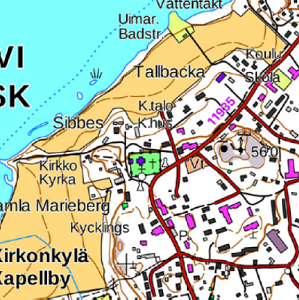
The Topographic map is a dataset depicting the terrain of all of Finland. The key elements in it are the road network, buildings and constructions, geographic names, waterways, land use and elevation. The more precise levels of the Topographic map consist of the same map objects and map symbols depicted in the same way as in the familiar Basic map. Basic map raster is applicable to be used, for instance, as a base map for planning land use or for excursion and outdoor recreational purposes in mobile devices and in various Internet services associated with nature. When going over to the more general datasets in the Topographic map, the number and visualisation of objects and map symbols changes. The generalised small-scale Topographic maps raster are applicable to be used as approach maps in e.g. mobile devices and Internet services. The product belongs to the open data of the National Land Survey of Finland.
-
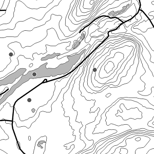
National Land Survey's Topographic map in vector format is a dataset depicting the terrain of all of Finland. The most important elements are the road network, administrative borders, preservation areas, population centres, geographic names, waterways, land use and elevation. The largest scale level (1:100,000) of the Topographic map in vector format is produced by generalising from the Topographic database. Topographic map 1:250,000 is produced by generalising the dataset 1:100,000. Topographic map 1:1,000,000 is produced by generalising the dataset 1:250,000. Topographic map 1:4,500,000 is produced by generalising the dataset 1:1,000,000. The geographic names have been generalised from the geographic names in the Geographic Names Register to map names suited to the scale in question. The administrative borders in the Municipal Division of each scale are used as administrative borders. The product belongs to the open data of the National Land Survey of Finland.